Gemini TerraPlan
An advanced visualization and analysis module for terrain and landscape planning, supporting slope, visibility, and sunlight analysis and clear communication of planning proposals.
Designed to support GIS-based workflows and 3D visualization in planning and design, enabling consistent analysis and presentation of terrain conditions.
Visualisation and landscape-analysis tools for terrain-based planning and design.
Gemini TerraPlan is an advanced add‑on module for Gemini Terrain, designed for professional visualisation, analysis, and animation. It provides an extended drawing library — Lightworks — that enables sun and shadow analysis, time‑based sunlight simulations, animation along map lines, and export of video animations. These capabilities make it easier to understand how landscapes behave over time and how planned interventions will appear in context.
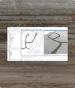
The module supports a wide range of GIS‑driven landscape analyses, including slope maps, exposure maps, sun/shadow maps, and visibility analyses. These thematic maps help you determine which areas are suitable for construction, which are exposed to risk, and where planning efforts should focus. Gemini TerraPlan also supports classic overlay analysis, combining properties across multiple datasets to identify optimal locations for development or areas requiring special consideration.
Gemini TerraPlan is especially useful for spatial and zoning planning. It helps municipalities and consultants create and visualize planning proposals, identify constraints early, and base decisions on detailed terrain and environmental conditions. Whether you're building housing plans, assessing exposure risks, or communicating design intent, Gemini TerraPlan provides the insight you need.
Specifications
Related products

Common questions about TerraPlan
Find answers here
The module can animate sunlight throughout the day (morning to evening on any date and location), as well as animations along map lines such as custom paths or road center lines. These animations can be exported as video files.
You can generate slope maps, exposure maps, sun/shadow maps, visibility analyses, and perform overlay analysis combining multiple data layers to identify optimal or sensitive areas.
It is ideal for planners, GIS analysts, municipalities, environmental consultants, and anyone working with land‑use planning, landscape analysis, or terrain‑based design.
Yes, the module supports preparation of planning and zoning proposals, helps identify suitable development areas, and provides thematic maps used in zoning processes.